We gaan weer op reis en de bestemming wordt West-Amerika. Op het programma staan, de IJSBA World Finals @ Lake Havasu, gevolgd door een rondreis door Arizona en Utah waar de verschillende Nationale Parken niet op het programma mogen ontbreken. Het wordt een intensieve vakantie met naast veel kilometers op de teller van de auto hopelijk ook wat kilometers in de beentjes. Hieronder alvast het resultaat van ettelijke uren reisvoorbereiding.

 29 september 2023 tot en met 22 oktober 2023
 29 – 30 september 2023
 Vluchtschema
| 10:25 Brussel, Brussels Airport (BRU) Vluchtduur: 1h00 | 11:25 Amsterdam, Amsterdam Schiphol Airport (AMS) |
| Uitgevoerd door: KLM, KL1724 Toestel: Boeing 737-700 Reisklasse Economy Class |
| 12:35 Amsterdam, Amsterdam Schiphol Airport (AMS) Vluchtduur: 10h35 | 14:10 Las Vegas, Harry Reid International Airport (LAS) |
| Uitgevoerd door: KLM, KL0635 Toestel: Boeing 787-9 Reisklasse Economy Class |
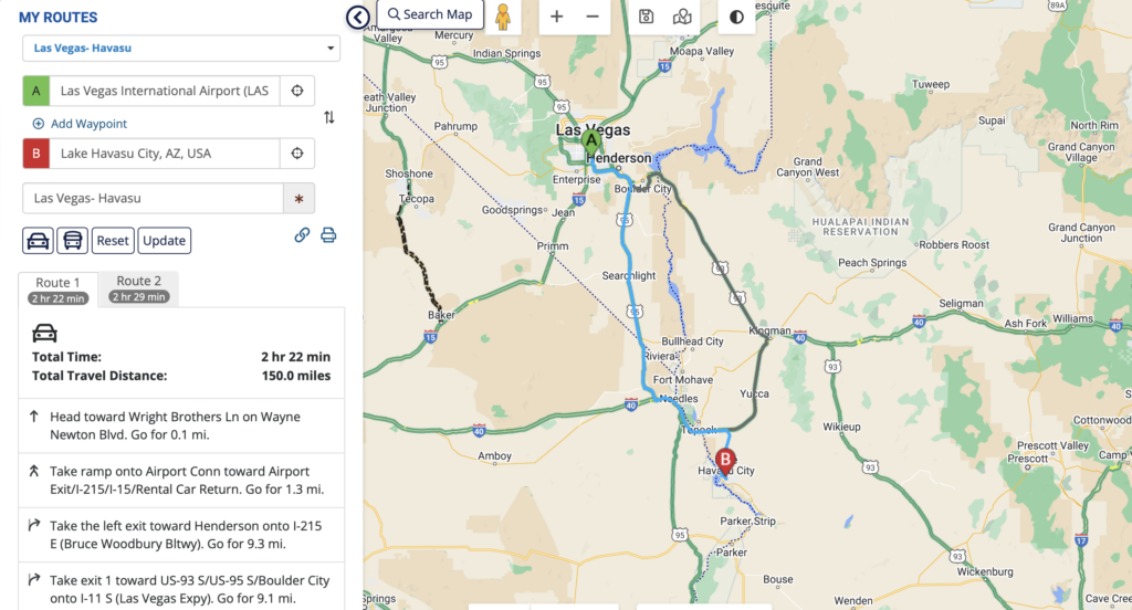
 Las Vegas – Lake Havasu City
 Route
Route
241,5 km
![]()
 Tijdzone Las Vegas
- PDT — Pacific Daylight Time
- UTC/GMT -7 hours – 9 hours behind Brussels
Tijdzone Lake Havasu City
- MST — Mountain Standard Time
- UTC/GMT -7 hours – 9 hours behind Brussels
1 oktober 2023
Lake Havasu City – Las Vegas
Onder voorbehoud
2 t.e.m. 9 oktober 2023
Las Vegas – Lake Havasu City
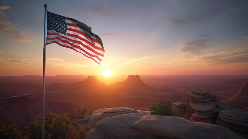
![]() IJSBA World Series: 2 t.e.m. 8 oktober
IJSBA World Series: 2 t.e.m. 8 oktober
![]() Oktober gemiddelde max. temperatuur 31°C – min. 17°C
Oktober gemiddelde max. temperatuur 31°C – min. 17°C
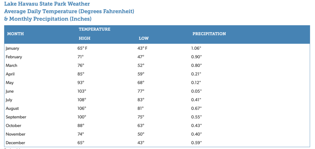
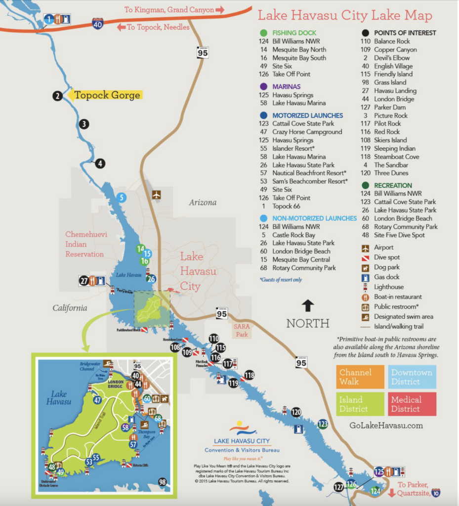
 Lake Havasu State Park
Lake Havasu
 Hikes in Havasu
10 oktober 2023
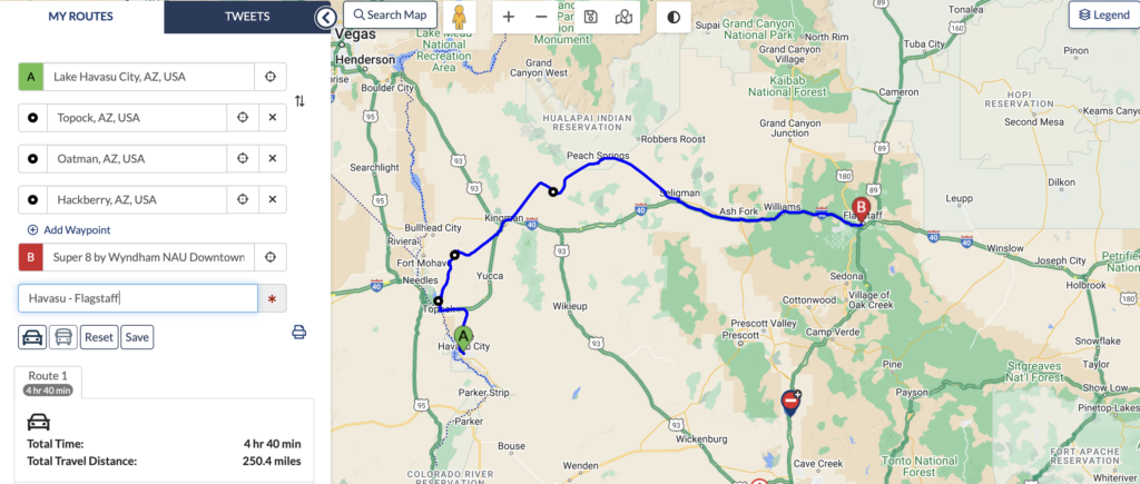
Lake Havasu City – Flagstaff
Route
402 km via Topock – Seligman – Oatman – Kingman – (indien tijd ook Williams)
![]() Super 8 by Wyndham NAU/Downtown Conference Center (1nacht) @ Flagstaff
Super 8 by Wyndham NAU/Downtown Conference Center (1nacht) @ Flagstaff
Tijdzone Flagstaff
- MST — Mountain Standard Time
- UTC/GMT -7 hours – 9 hours behind Brussels
 Daginvulling
 Route 66 to Flagstaff
11 oktober 2023
Flagstaff – Grand Canyon N.P.
Route
290 km
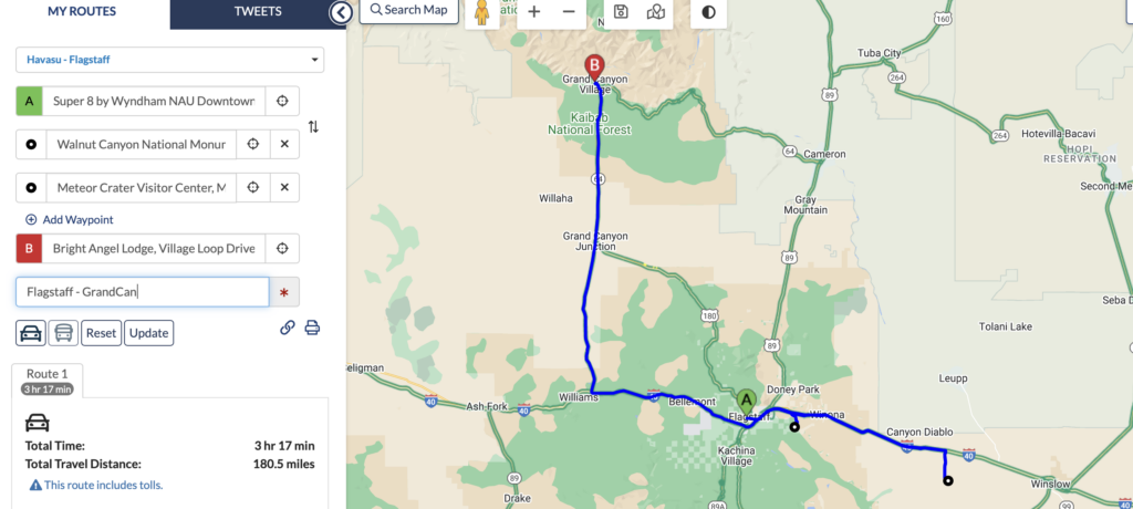
Van Meteor Crater tot Bright Angel Lodge: 211 km – 2u 8′ rijden
![]() Bright Angel Lodge (2 nachten) @ Grand Canyon N.P.
Bright Angel Lodge (2 nachten) @ Grand Canyon N.P.
![]() Entry Fee Grand Cayon en Walnut Canyon N.P.: Interagency Pass
Entry Fee Grand Cayon en Walnut Canyon N.P.: Interagency Pass
Tijdzone Grand Canyon
- MST — Mountain Standard Time
- UTC/GMT -7 hours – 9 hours behind Brussels
Daginvulling
Walnut Canyon N.P.
 Weather
Be prepared for variable and extreme weather conditions. You may expect high winds any time of year, summer temperatures above 95ºF (35ºC), afternoon storms July–September, and heavy snow from fall to spring. Dress in layers, as weather at Walnut Canyon can change quickly at any time of year.
![]()
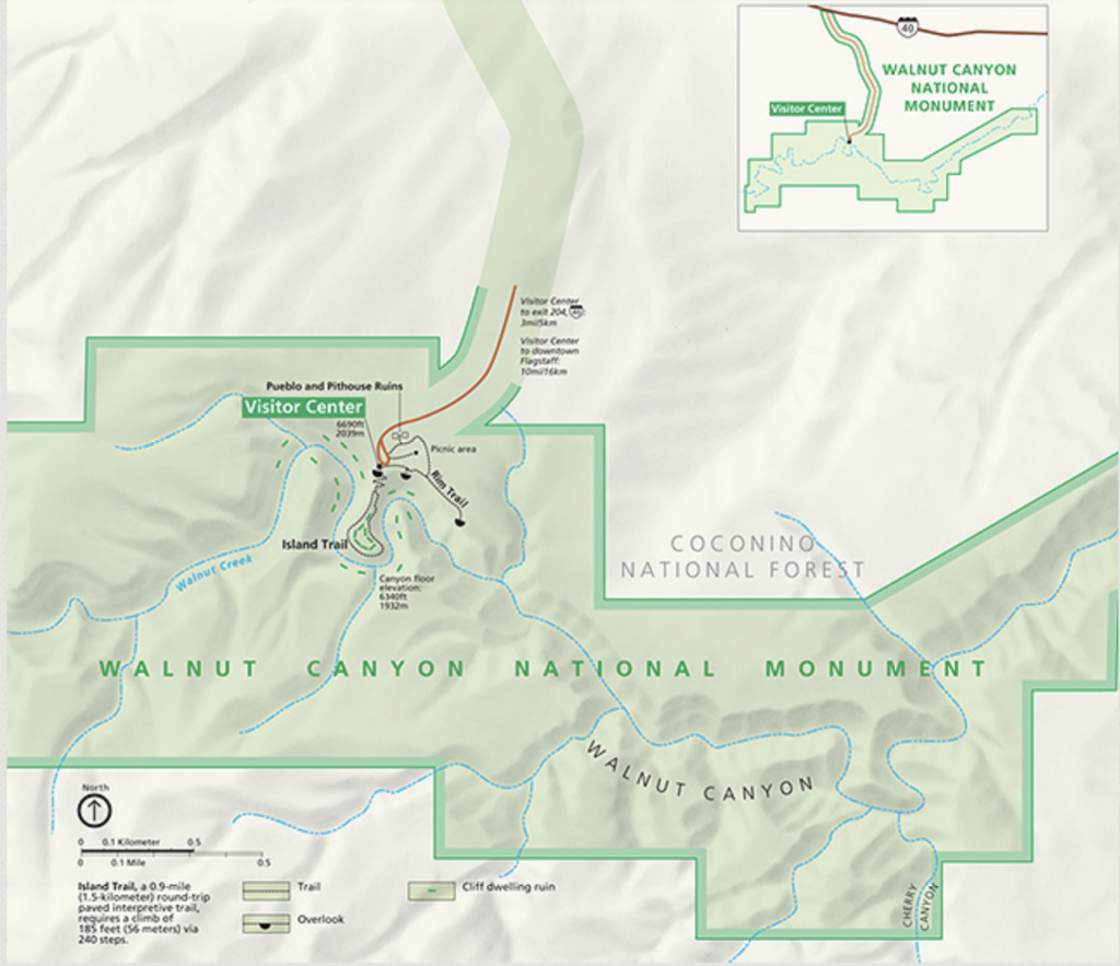
Hikes
- Islands Trail
It has been more than 700 years since Walnut Canyon echoed with the voices and sounds of a robust pueblo community. Today, the Island Trail leads you back in time, and welcomes you into the world of the Native people archeologists call Sinagua. You’ll experience 25 cliff dwelling rooms along the trail; and gaze at others visible across the canyon.
| Distance | 1 mile round-trip |
| Time | 1 hour round-trip |
| Difficulty | Strenuous, especially for those not acclimated to 7,000′ elevation. The trail descends 185 vertical feet into the canyon, and returns the same way. |
| Accessibility | The trail is paved, but not accessible to wheelchairs, due to steep canyon terrain and many stairs. |
- Rim Trail
The Rim Trail will be partially open from May – October for trail work. During this closure the first viewpoint and path to the junction will be available. The trail to the second viewpoint, the pueblo, and pit house will be closed.
Stroll along the canyon rim through a mixed juniper and pinion pine forest. Two canyon overlooks provide scenic views of the canyon and cliff dwellings below. Explore a partially rebuilt pithouse and pueblo set back from the canyon rim. On a summers day, visit the demonstration garden that features traditional crops grown by the Sinagua.
| Distance | 0.7 mile round-trip |
| Time | 30 minutes round-trip |
| Difficulty | Easy, fairly level. |
| Accessibility | The first part of the trail, leading to the first canyon overlook, is paved and accessible. Ask at the visitor center before proceeding further. |
Meteor Crater
![]() 27 $/volwassene, inbegrepen attracties:
27 $/volwassene, inbegrepen attracties:
- The Meteor Crater
- Lookout Points
- Guided Rim Tours
- Discovery Center & Space Museum
- COLLISION! 4D Theater
- Impact! The Mystery of Meteor Crater
- Apollo 11 Space Capsule
![]()
- Interstate 40, Exit 233, Winslow, AZ 86047
- Winter Hours: Open Daily 8AM—5PM
12 oktober 2023
Daginvulling
Grand Canyon N.P.
![]()
Average Temperatures on the South Rim (by month)
Oktober gemiddelde max. temperatuur 18 °C – min. 2 °C.
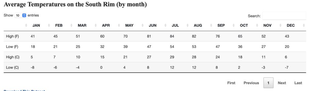
Fall
The summer heat gives way to a cooler but nonetheless pleasant fall period with average high temperatures gradually falling from the 60s (16-21°C) in September through the 50s (10-15°C) by November along the Rim, and from the 90s (32-37°C) in September to near 70 (21°C) by November along the river. Low temperatures will typically fall below freezing on the Rim, but still remain in the warm 50s and 60s (10-21°C) along the river. The summer rains typically diminish in mid September with a drier fall period the norm with fewer days of precipitation. However, late summer thunderstorms or early winter snow storms have been known to take place during this transition season, making for sudden changes to the weather.
 Bike
Bike
Bright Angel Bicycles Booking
Sm/Medium 5’0″ – 5’9″ eBike | Full Day (2)
Thu Oct 12, 2023
08:00 AM – 05:00 PM
- Yellow Bike Route
This route is recommended only if you’re very fit OR if you rent electric bikes to assist your ride. It will navigate you directly from our shop via the village to the Hermit Road and all the way to Hermit’s rest.
Difficulty: Challenging Due to Distance/Hills
Duration: 2.5-6 Hours
One Way Distance: 10.5 Miles / 16.8km
Round Trip Distance: 21 Miles / 33.6 km
- Orange Bike Route
The orange route is accessible by directly from our shop out to the nearby paved pathway system that leads to the Yaki trail. It weaves it’s way through forest and across a road and then spends the rest of it’s duration on paved rim-side trail.
Difficulty: Easy/Moderate
Duration: 1-2 Hours
One Way Distance: 3.5 Miles /5.6km
Round Trip Distance: 7 Miles / 11.2 km
13 oktober 2023
Grand Canyon N.P. – Page
Route
302 km
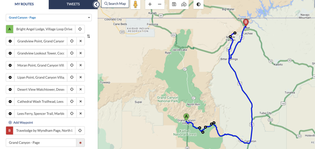
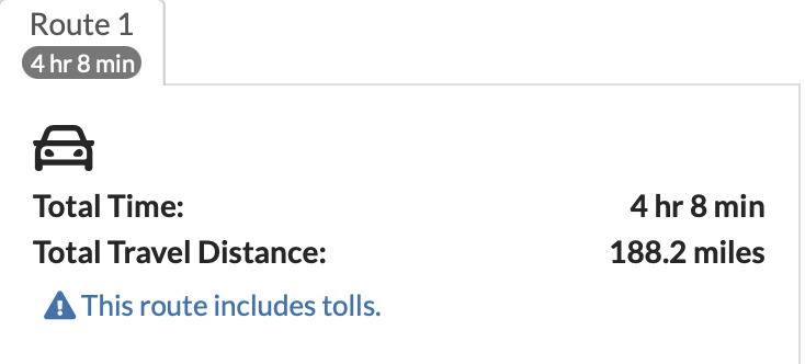
Van Cathedral Wash naar hotel: 66 km 45′ rijden
![]() Travellodge by Wyndham (1 nacht) @ Page
Travellodge by Wyndham (1 nacht) @ Page
Tijdzone Page
- MST — Mountain Standard Time
- UTC/GMT -7 hours – 9 hours behind Brussels
Daginvulling
East Rim Grand Canyon – Desert View Drive
![]() 37 km lang
37 km lang
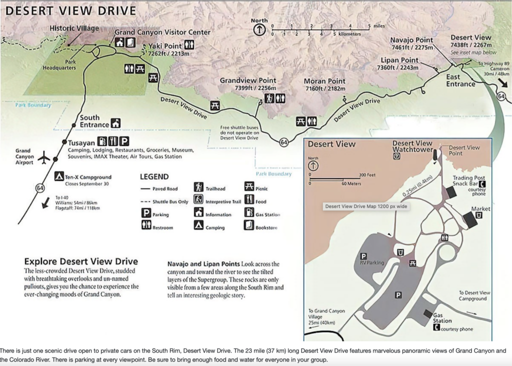
 Overlooks
- Grandview Point,
- Moran Point,
- Lipan Point,
- Navajo Point,
- Desert View Point (watch tower)
+ eventueel Grandview Lookout Tower
Directions:
Grandview Lookout Tower is located approximately 10 miles east of the Tusayan Ranger District Office. Take FR 302 east from Highway 64/180, just south of the town of Tusayan. Follow FR 302 for about 15 miles to its junction with FR 310. Turn left onto FR 310 and the lookout tower will soon appear on your right. The gravel and graded dirt roads are suitable for passenger vehicles.
Glen Canyon National Recreation Area
![]() Oktober gemiddelde max. temperatuur 22°C – min. 9°C
Oktober gemiddelde max. temperatuur 22°C – min. 9°C
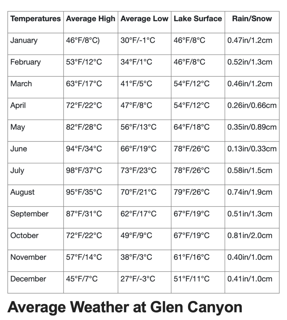
Lees Ferrys
Lees Ferry is located off US Hwy 89A, about 45 miles south of Page AZ. At Marble Canyon, turn off onto the Lees Ferry Road, and in about half a mile stop at the Entrance Station. Use the automated fee machine for your entrance fee and all relevant passes. No cash, the machine accepts cards only.
Lees Ferry is the only place within Glen Canyon where visitors can drive to the Colorado River in over 700 miles of canyon country, right up to the first rapid in the Grand Canyon. A natural corridor between Utah and Arizona, Lees Ferry figured prominently in the exploration and settlement of northern Arizona. Lees Ferry is now a meeting of the old and the new.
Here at the very start of the Grand Canyon, adventurous river runners launch their boats for trips down the canyon. Fishermen enjoy world-class trout fishing upstream to Glen Canyon Dam. Backpackers finish their 4 or 5 day hike through the Paria Canyon Wilderness Area here. Hikers can explore canyons and desert ridges.
Cathedral Wash
Distance: 3 miles (4.8 km) round-trip
Moderate
Canyon walls rise as you follow a mostly dry wash to the Colorado River. This adventure has no major technical challenges, but scrambling and careful decision-making are needed to choose safe routes over ledges and dropoffs. Named after church-like Cathedral Rock at the head of this small canyon, your journey will take you deeper and deeper through Kaibab Limestone and Toroweap Formations until ending at the river, where canyon debris created Cathedral Wash Rapid.
Some rock scrambling and wayfinding required. Do not hike when there is a potential for flash flooding. Bring plenty of water and avoid hiking during the hottest part of the day.
Trailhead: Follow the Lees Ferry access road 1.3 miles (2.1 km). The trailhead is at the pull out on your left. You can access both upper and lower Cathedral Wash from this parking area. No overnight parking.
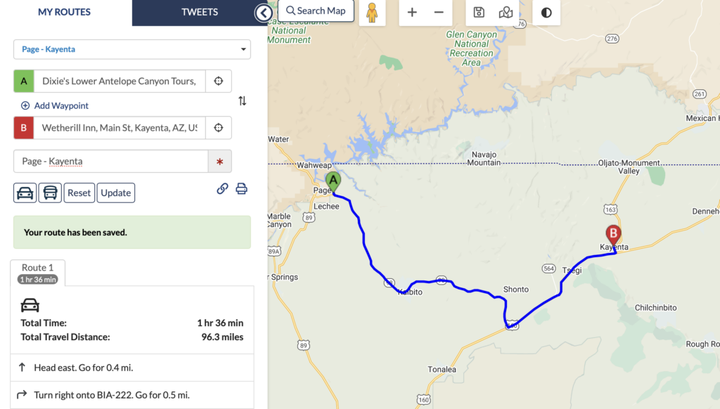
14 oktober 2023
Page – Kayenta
Route
154,5 km
![]() Wetherill Inn (1 nacht) @ Kayenta
Wetherill Inn (1 nacht) @ Kayenta
Tijdzone Kayenta en Monument Valley
![]() + 1 uur
+ 1 uur
- MDT — Mountain Daylight Time
- UTC/GMT -6 hours – 8 hours behind Brussels
Daginvulling
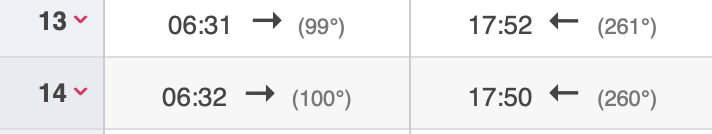
Horseshoe Bend
2,4 km wandelen A/R naar uitzichtpunt
![]()
Horseshoe Bend is open year-round from sunrise to sunset. Our busiest times of the day are between 9:00am to 11:00am in the morning and 4:30pm to 6:30pm in the evening. If you enjoy fewer crowds, try scheduling your hike around these busy times. There is no overnight parking or camping allowed.
Sunrise/sunset
![]() We accept both cash and credit card at the fee booth.NOTE: ONLY CASH WILL BE ACCEPTED ON HOLIDAY WEEKENDS
We accept both cash and credit card at the fee booth.NOTE: ONLY CASH WILL BE ACCEPTED ON HOLIDAY WEEKENDS
Horseshoe Bend Fees are as follows: Car or RV: $10
2023 Annular Eclipse
Zonsverduistering: ringeclips vanaf Horseshoe Bend of bij Wahweap Bay indien te druk verkeer gelet op halve marathon en excursie om 1 P.M.
![]() Lake Powell Half Marathon: start om 6.30 A.M. => verkeershinder
Lake Powell Half Marathon: start om 6.30 A.M. => verkeershinder


![]()
Antelope Canyon Photo Excursion om 1 P.M. (duur: 2u) => geannuleerd door Lake Powell Experience
- check in at the dock 15’ early.
- Adres: 100 Lake Shore Drive, Page, AZ 86040 (zie Link G Maps in mail).
- Antelope Canyon, Glen Canyon Dam, Wahweap Bay
![]()
Lower Antelope Canyon met Dixie’s om 4:15P.M. tot 5:15 P.M. => geannuleerd en andere excursie geboekt
- 45’ op voorhand aanwezig zijn
- Adres: Indn, Route 222 Page, AZ 86040
![]() Secret Antelope Canyon & Horseshoe Bend met Horseshoe Bend slot canyon tours
Secret Antelope Canyon & Horseshoe Bend met Horseshoe Bend slot canyon tours
15 oktober 2023
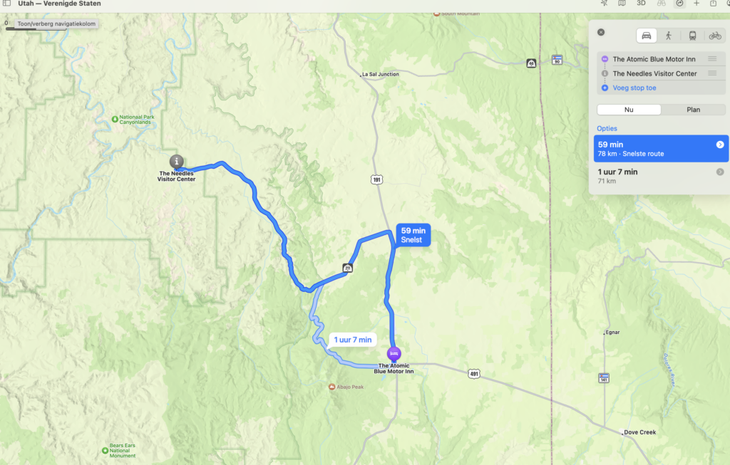
Kayenta – Monument Valley – Monticello
Route
272 km (zonder de Monument Valley lus (27 km)). Indien geen tijd Natural Bridges N.P. laten vallen.

vanaf Natural Bridges N.P. 1u rijden naar hotel in Monticello
![]() The Atomic Blue Motor-Inn (1 nacht) @ Monticello
The Atomic Blue Motor-Inn (1 nacht) @ Monticello
Tijdzone Monticello
- MDT — Mountain Daylight Time
- UTC/GMT -6 hours – 8 hours behind Brussels
Daginvulling
![]() 29 ‘ rijden tot
29 ‘ rijden tot
Monument Valley:
- Scenic Drive: October 1 – March 30 (Off Season): 8 a.m. – 4 p.m., Monday thru Friday, MST.
- Park Entry Fee: $8 per person, per entry, per location + $20 auto, to enter the 17 mile loop drive (27 km). (Valley drive encourages Guided Tours) We do not accept National Park Passes.
- 2u à 2u30 voor de rondrit incl. fotostops
- https://navajonationparks.org/navajo-tribal-parks/monument-valley/
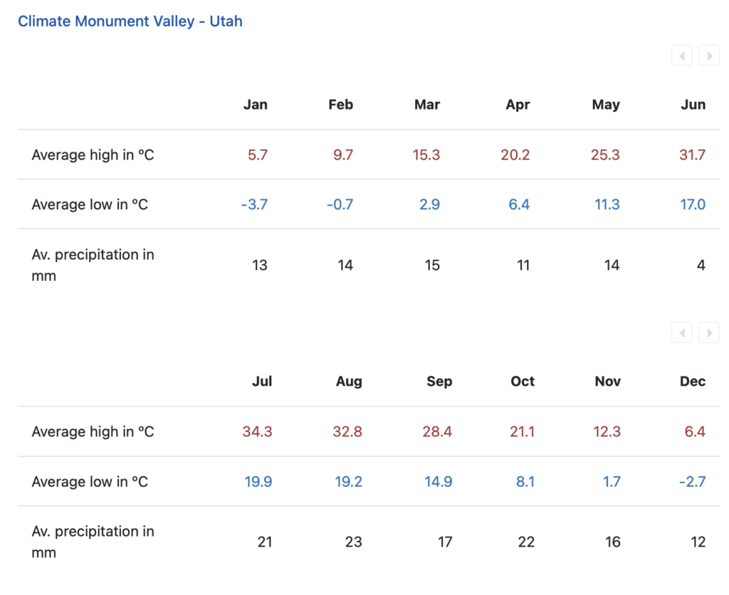
![]() Oktober gemiddelde max. temperatuur 21°C – min. 8°C
Oktober gemiddelde max. temperatuur 21°C – min. 8°C
![]() 41′ rijden tot
41′ rijden tot
Goosenecks State Park
![]() 12′ rijden tot
12′ rijden tot
![]() 5$/auto
5$/auto
Valley of the Gods (lus van +/- 27 km = 1u rijden)
Overlooks
![]() 40′ rijden tot Muley Point Overlook
40′ rijden tot Muley Point Overlook
![]() 50′ rijden tot
50′ rijden tot
Natural Bridges N.P.
![]() Entry Fee: Interagency Pass
Entry Fee: Interagency Pass
![]()
Southeast Utah is part of the Colorado Plateau, a “high desert” region that experiences wide temperature fluctuations, sometimes over 40 degrees in a single day. The temperate (and most popular) seasons are spring (April through May) and fall (mid-September through October), when daytime highs average 60° to 80°F (15,5°C tot 26,5°C) and lows average 30° to 50°F (-1°C tot 10°C) . Summer temperatures often exceed 100°F, making strenuous exercise difficult. Late summer monsoon season brings violent storm cells which often cause flash floods.
Winters are cold, with highs averaging 30° to 50°F, and lows averaging 0° to 20°F. Though large snowfalls are uncommon (except in nearby mountains), even small amounts of snow or ice can make local trails and roads impassable.
![]()
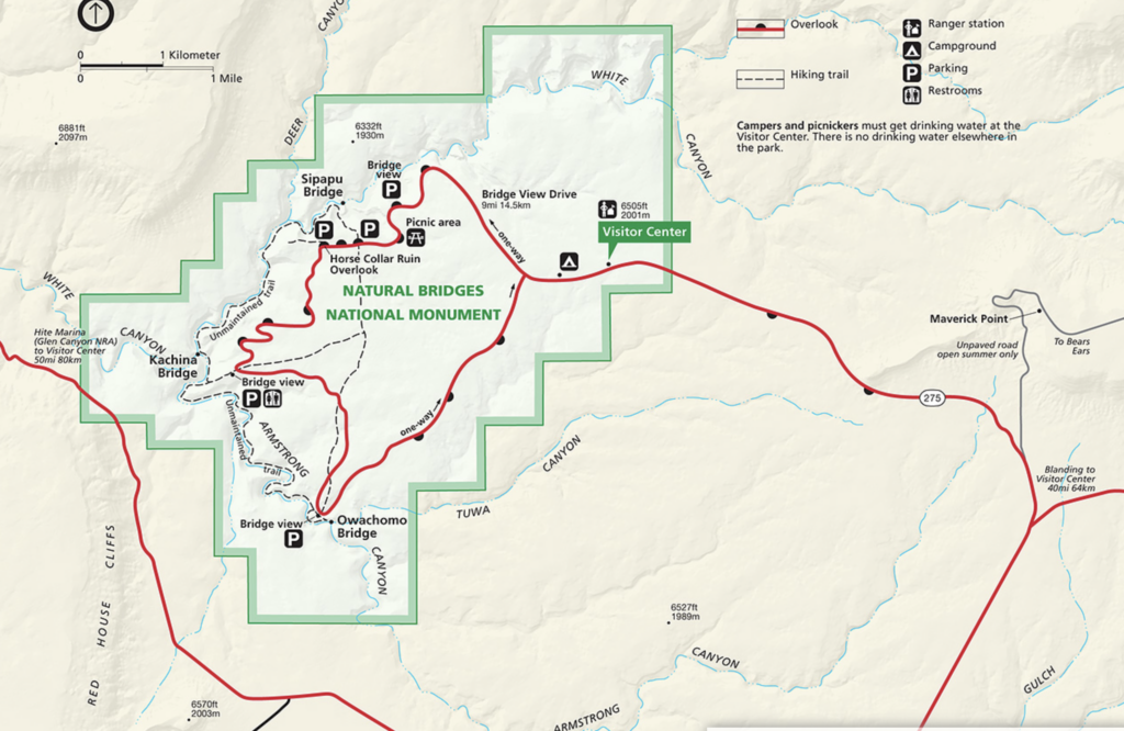
![]() Bridge View Drive: 9 miles
Bridge View Drive: 9 miles
Overlooks
- Sipapu Bridge Viewpoint
- Kachina Bridge viewpoint
- Owachomo Bridge viewpoint:
Hikes
Once named “Little Bridge,” Owachomo Bridge is the smallest natural bridge in the park. Its thin structure suggests that Owachomo may also be the oldest. Hiking to Owachomo provides a rare peek into the monument’s history.
Length Roundtrip: 0.5 miles (0.84 kilometers)
Elevation Change One-way (from Rim to Base): 188 feet (57.3 meters) loss
![]() vanaf Natural Bridges N.P. 1u rijden naar hotel in Monticello
vanaf Natural Bridges N.P. 1u rijden naar hotel in Monticello
16 oktober 2023
Monticello – Moab
Route
Hotel naar The Needles District: 71 km
Totaal: 321 km, incl. overlooks. ! Google-maps geeft niet dezelfde tijdsaanduiding als Utah UDOT traffic. Vanaf Highway 191: 1u tot Needles overlook en 1,5u tot Anticline overlook.
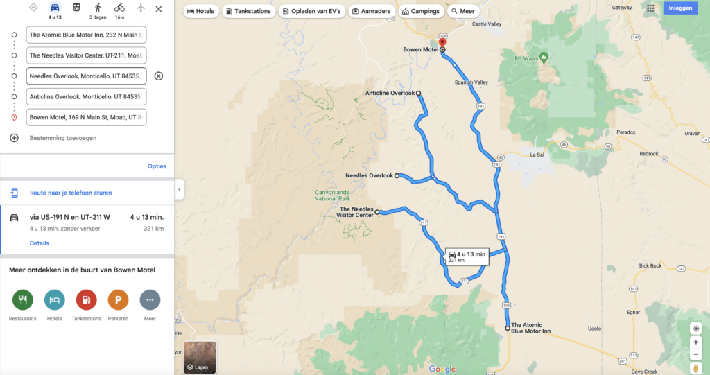
Needles overlook tot Bowen Motel = 87 km of 1u51′ rijden
![]() Bowen Motel (2 nachten) @ Moab
Bowen Motel (2 nachten) @ Moab
Tijdzone Moab
- MDT — Mountain Daylight Time
- UTC/GMT -6 hours – 8 hours behind Brussels
Canyonlands N.P. :
- Islands in the Sky
- The Needles
- The Maze
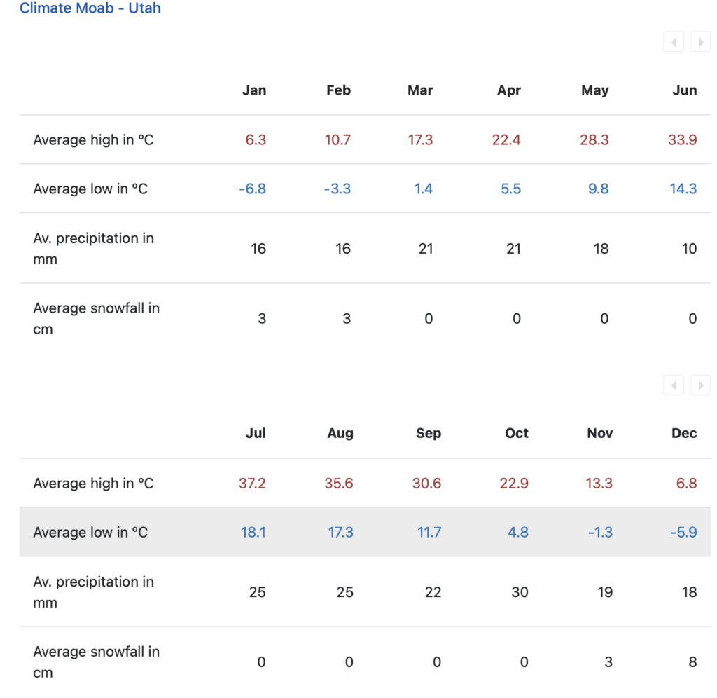
![]() Oktober gemiddelde max. temperatuur: 15,8°C – min. 0,9°C
Oktober gemiddelde max. temperatuur: 15,8°C – min. 0,9°C
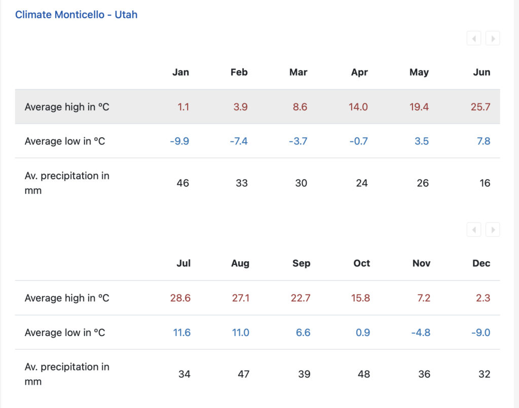
Mid-September through October, daytime highs average 60º to 80ºF (15º to 26ºC) and lows average 30º to 50ºF (-1º to 10ºC) .
Daginvulling
The Needles District
![]() Entry Fee: Interagency Pass
Entry Fee: Interagency Pass
Hikes
- Slickrock trail => 2,4 miles (loop), +/- 1,5 à 2u = ongeveer 4 km
- Pothole Point => 0,6 miles, 45′ = ongeveer 1 km
Kaart met viewpoints en hikes
Overlooks
- Needles Overlook
- Anticline Overlook
![]() NEEDLES / ANTICLINE OVERLOOKS SCENIC BACKWAY – COUNTY ROAD 133
NEEDLES / ANTICLINE OVERLOOKS SCENIC BACKWAY – COUNTY ROAD 133
Drive west off US Highway 191 to the Needles and Anticline Overlooks at the edge of a 1000 foot cliff. The La Sal Mountains rise in the distance in contrast to the sweeping desert below the overlooks. Windwhistle and Hatch Point Campgrounds are available. This Backway is open year round, although a winter snow storm may close the road temporarily. Allow 1 hour to reach the Needles Overlook and 1 1/2 hours to reach Anticline.
=> afhankelijk van de tijd beperken tot Needles Overlook. Indien genoeg tijd, eerst Anticline en op de terugweg Needles. Volgens Utah Udot Traffic is het 2u15′ (90 km) tot hotel vanaf Anticline .
17 oktober 2023
 Moab
Moab
![]() Oktober gemiddelde max. temperatuur: 22,9°C – min. 4,8°C
Oktober gemiddelde max. temperatuur: 22,9°C – min. 4,8°C
Daginvulling
Dead Horse Point State Park
Hikes
Parkeren aan Visitor Center en East Rim Trail tot Dead Horse Point Overlook wandelen, dan terug naar Visitor Center via West Rim Trail. Of in omgekeerde volgorde
Ongeveer 5.5 miles met optionele overlooks op de trail (ongeveer 9 km).
Overlooks on the hike:
- Basin overlook
- Meander overlook
- Shafer Canyon overlook
- Rim overlook
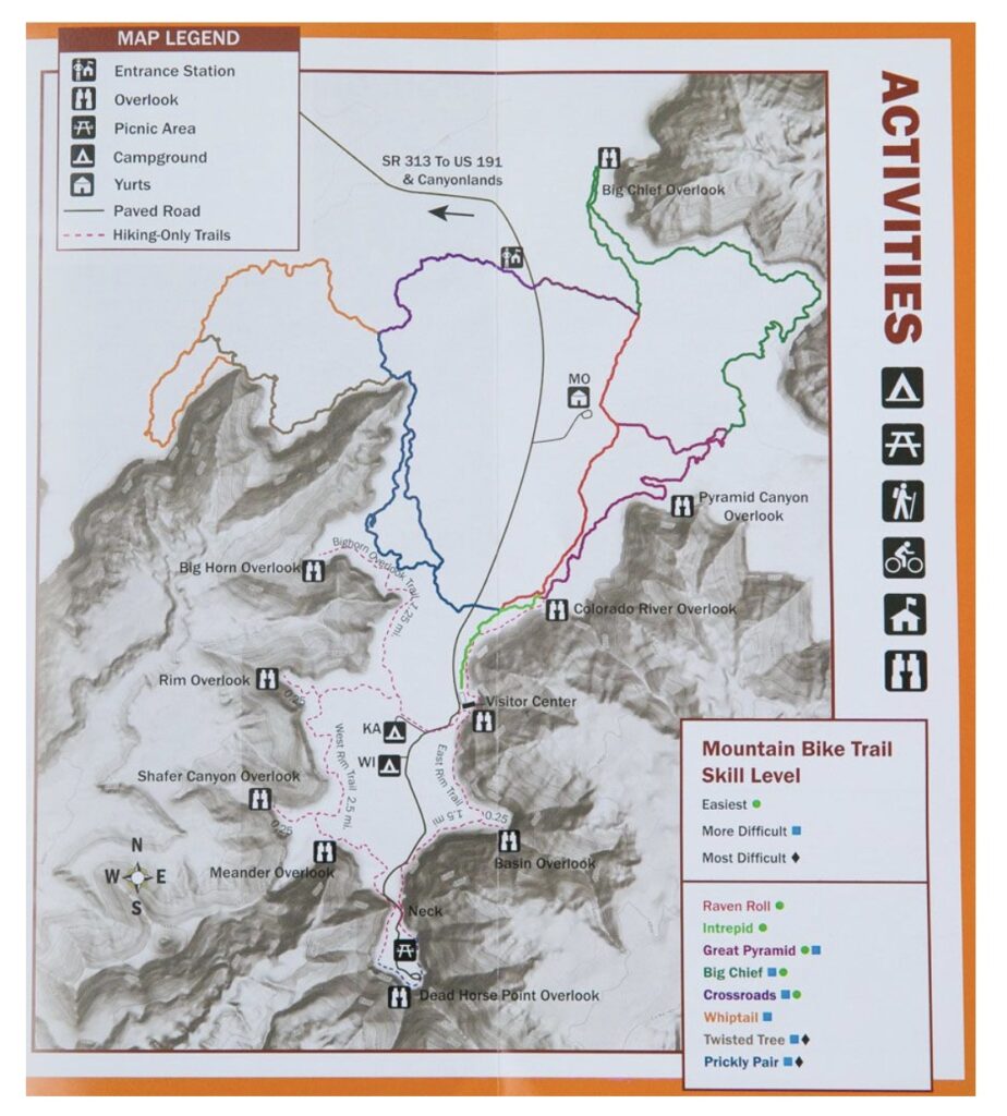
Islands in the Sky District
Overlooks
- Visitors center overlook
- Shafer Canyon overlook en Shafer Trail Viewpoint (Parkeren op kleine parking op Grand View Road voor dichter uitzicht op Shafer Trail.)
- Grand View Point: op het einde van Grand View Point Road. Grote parking en korte wandeling tot viewpoint.
- Buck Canyon Overlook
- Green River Overlook: Afslag ligt op Upheaval Dome Road, juist voorbij kruising met Grand View Point Road. Grote parking Len toilet. Korte wandeling tot viewpoint.
Hikes
- White Rim Overlook: 2,9 km, 1,5u. Beperkte parking. Zuidwaards op Grand View Point Road, afslag links naar picnic area. Daar kan geparkeerd worden of aan de beperkte plaatsten aan de start van de trail. De afslag bevindt zich 11 mijl van het Visitor Center.
- Mesa Arch: 1 km, 30′
- Upheaval Dome to first overlook: 1 km, 1u
Kaart met viewpoints en hikes
18 oktober 2023
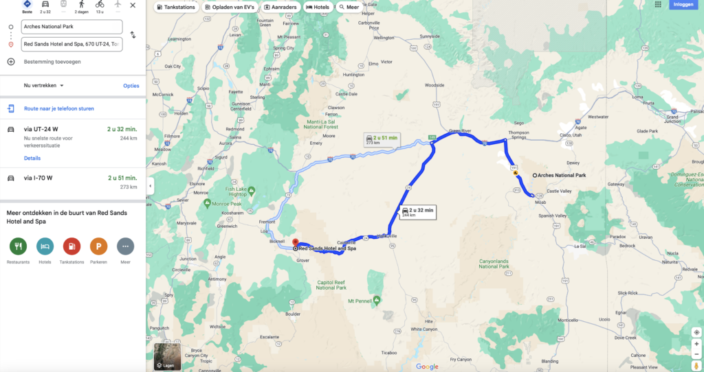
Moab – Torrey
Route
244 km
![]() Red Sands Hotel (1 nacht) @ Torrey
Red Sands Hotel (1 nacht) @ Torrey
Tijdzone Torrey
- MDT — Mountain Daylight Time
- UTC/GMT -6 hours – 8 hours behind Brussels
![]() Torrey oktober gemiddelde max. temperatuur 18,8°C – min. 5,8°C
Torrey oktober gemiddelde max. temperatuur 18,8°C – min. 5,8°C

Daginvulling
![]() 7 km = 7′ rijden tot
7 km = 7′ rijden tot
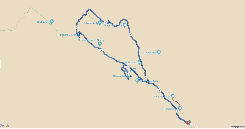
Arches N.P.
Verplichte reservatie timeslot! Gereserveerd tussen 7 en 8 A.M.
![]() Oktober gemiddelde max. temperatuur: 22,7°C – min. 6,6°C
Oktober gemiddelde max. temperatuur: 22,7°C – min. 6,6°C
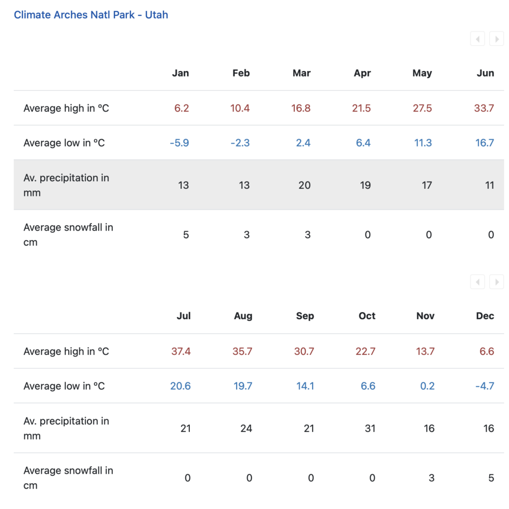
Southeast Utah is part of the Colorado Plateau, a “high desert” region that experiences wide temperature fluctuations, sometimes over 40 degrees in a single day. The temperate (and most popular) seasons are spring (April through May) and fall (mid-September through October), when daytime highs average 60º to 80º F (15,5° tot 26,5°C) and lows average 30º to 50º F (-1° tot 10°C).
Summer temperatures often exceed 100ºF, making strenuous exercise difficult. Late summer monsoon season brings violent storm cells which often cause flash floods. Roads can close following rain or snow.
Winters are cold, with highs averaging 30º to 50º F, and lows averaging 0º to 20º F. Though large snowfalls are uncommon (except in nearby mountains), even small amounts of snow or ice can make local trails and roads impassable.
![]()
Hikes
Zie https://www.earthtrekkers.com/one-day-in-arches-national-park-itinerary/
- Starten met LANDSCAPE ARCH & THE DEVILS GARDEN TRAIL
Overlooks overslaan en onmiddellijk naar daar doorrijden.
Landscape Arch
Double O Arch
Navajo and Partition Arches
Totaal 9,5 km
- DELICATE ARCH
Als laatste bezoeken! Beste licht op einde van de dag.
5 km: 2 tot 3u. Start aan Wolfe Ranch, niet aan de viewpoints!
 Paved Roads
The scenic drive in Arches passes many outstanding natural features. Parking is limited at all destinations, and popular trailheads like Delicate Arch and Devils Garden may fill for hours at a time, especially on weekends and holidays. View the Traffic & Travel Tips page for advice on making the most of your time (and avoiding the crowds).
If you have 1.5 hours
- Drive to The Windows Section and see some of the park’s largest arches. (Add a half hour to stroll beneath either North Window or Double Arch.).
Doen: Garden of Eden (panoramic view over Arches National Park, Turret Arch and the Windows, with the La Sal Mountains as a backdrop) en Double Arch (1 km, 15 à 30′). Balanced Rock en the Three Gossips bij uitrijden park.
- Or drive to Delicate Arch Viewpoint and see the world’s most famous arch, a mile distant. Stop at Wolfe Ranch on your way back and imagine what it would have been like to homestead this relatively barren area in the late 1800s.
Zie hike!
If you have 3 hours
Do both of the above.
If you have 4.5 hours
Drive all of the paved park roads, spending 10 minutes at each viewpoint, and be sure to visit The Windows Section, Wolfe Ranch and Delicate Arch Viewpoint.
19 oktober 2023
Torrey – Ruby’s Inn
Route
Zie ook https://capitolreefcountry.com/scenic-byway-12/

![]() Best Western PLUS Ruby’s Inn (1 nacht) @ Ruby’s Inn
Best Western PLUS Ruby’s Inn (1 nacht) @ Ruby’s Inn
Tijdzone Ruby’s Inn
- MDT — Mountain Daylight Time
- UTC/GMT -6 hours – 8 hours behind Brussels
Daginvulling
Capitol Reef N.P.
![]()
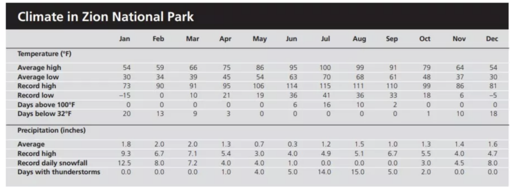
Weather Averages
The following chart shows temperature and precipiation averages from 1991 through 2020. Record temperatures and maximum precipitation are from weather data collected between 1938 and 2020.
| Month | Average Temperature (°F) | Record Temperature (°F) | Precipitation (in.) | Snowfall (in.) | ||||
|---|---|---|---|---|---|---|---|---|
| High | Low | High | Low | Average | Maximum | Average | Maximum | |
| January | 41 | 20 | 69 | -9 | 0.52 | 2.32 | 3.9 | 23.3 |
| February | 47 | 26 | 72 | -7 | 0.54 | 2.92 | 1.9 | 17.0 |
| March | 58 | 34 | 80 | 10 | 0.48 | 2.25 | 1.5 | 16.5 |
| April | 65 | 39 | 91 | 18 | 0.51 | 2.84 | 0.5 | 12.5 |
| May | 74 | 48 | 97 | 28 | 0.63 | 2.23 | – | 2.5 |
| June | 87 | 58 | 104 | 35 | 0.35 | 2.29 | – | – |
| July | 91 | 65 | 104 | 44 | 1.05 | 3.54 | – | – |
| August | 88 | 63 | 102 | 42 | 1.14 | 4.42 | – | – |
| September | 80 | 55 | 99 | 30 | 0.97 | 5.18 | – | – |
| October | 66 | 43 | 91 | 12 | 0.85 | 5.22 | – | 10.1 |
| November | 51 | 31 | 77 | 5 | 0.51 | 2.84 | 1.5 | 18.0 |
| December | 40 | 21 | 69 | -8 | 0.35 | 2.15 | 2.9 | 21.5 |
Hikes
- GOOSENECKS & SUNSET POINT
Two very short hikes start from one parking lot. From Highway 24, turn onto the gravel road for Panorama Point and Sunset Point. Panorama Point will be the first overlook you will come to. Simply step out of your car and enjoy the view. Then, continue down the gravel road to the end and park in the parking lot. This road is suitable for standard cars.
SUNSET POINT
Distance: 0.8 miles | Difficulty: Easy | Time: 20 to 30 minutes
This is a short, easy hike out to a gorgeous overlook. It gets its name because it is one of the best spots in Capitol Reef to watch the sunset, but the views are beautiful all day long.
GOOSENECKS OVERLOOK
Distance: 0.2 miles | Difficulty: Easy | Time: 10 minutes
This short walk takes you to an overlook where the Sulphur Creek carved out a canyon, its curving path resembling that of a gooseneck.
- HICKMAN BRIDGE
Distance: 1.8 miles | Difficulty: Moderate | Total Ascent: 400 feet | Time: 2 to 3 hours (+/- 3 km)
This is one of the best short hikes to do in Capitol Reef. Walk along the Fremont River and then hike up to a spectacular viewpoint where you can look out over Highway 24. The trail ends at Hickman Bridge, a large, natural arch that is tucked away near the back of the canyon.
- GRAND WASH
Distance: 4.8 miles* | Difficulty: Easy | Total Ascent: Minimal | Time: 2 hours (+/- 8 km)
This is a long hike if you walk the entire length of the canyon, but you can turn around when you are ready. The best part of the hike, where the canyon is the narrowest (called The Narrows), is about one mile from the start, so you can see the best of the Grand Wash if you only hike 2 to 3 miles round trip.
Scenic Drive
The Scenic Drive starts at the park Visitor Center and provides access to Grand Wash Road, Capitol Gorge Road, Pleasant Creek Road, and South Draw Road. The Scenic Drive is a 7.9 mile (12.7 km) paved road with dirt spur roads into Grand Wash and Capitol Gorge that, weather permitting, are accessible to all passenger vehicles and RV’s up to 27 feet in length. The Scenic Drive is not a loop, so you must return on the same road. An entrance fee of $20 per vehicle is charged for the Scenic Drive. The self-pay entrance station is located just south of the campground on the Scenic Drive. There is no entrance fee for holders of the America the Beautiful – National Parks and Federal Recreation Lands passes. A “Guide to the Scenic Drive” brochure is available at the visitor center bookstore or follow this link for a virtual tour of the Geology of the Scenic Drive. There is also a self-guided tour to the Scenic Drive in the NPS app.
National Scenic Byway (route) 12: Kodachrome Basin State Park
20 oktober 2023
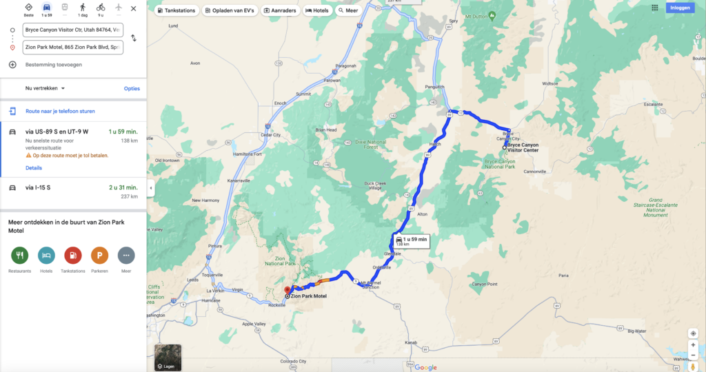
Ruby’s Inn – Springdale
Route
138 km
![]() Zion Park Motel: 2 nachten @ Springdale
Zion Park Motel: 2 nachten @ Springdale
Tijdzone Springdale
- MDT — Mountain Daylight Time
- UTC/GMT -6 hours – 8 hours behind Brussels
Daginvulling
Bryce Canyon
![]() Entry Fee: Interagency Pass
Entry Fee: Interagency Pass
Weather Averages
Due of its high elevation climate, weather at Bryce Canyon through autumn, winter, and spring can be highly variable. Check current conditions for any weather-related closures, and the current National Weather Service forecast for Bryce Canyon. If you’ll be driving, you can check area road conditions by visiting Utah Department of Transportation’s Traffic Site.
Snowstorms in October are not unusual, yet there are also many sunny and pleasant autumn days during the month. From October to May temperatures fall below freezing nearly every night. The park typically experiences its coldest and snowiest periods from December through February. Spring storms in March and April can still produce heavy snowfall that may impact travel in the region.
In summer the days tend to be pleasant, with daytime highs in June typically in the high 60s to low 70s (F), high 70s to low 80s in July and August, while September is similar to June. The rainy season occurs in July and August with frequent, usually brief, afternoon thunderstorms which produce heavy rain and frequent lightning. If visiting during these months remember that lightning kills and “when thunder roars go indoors!”
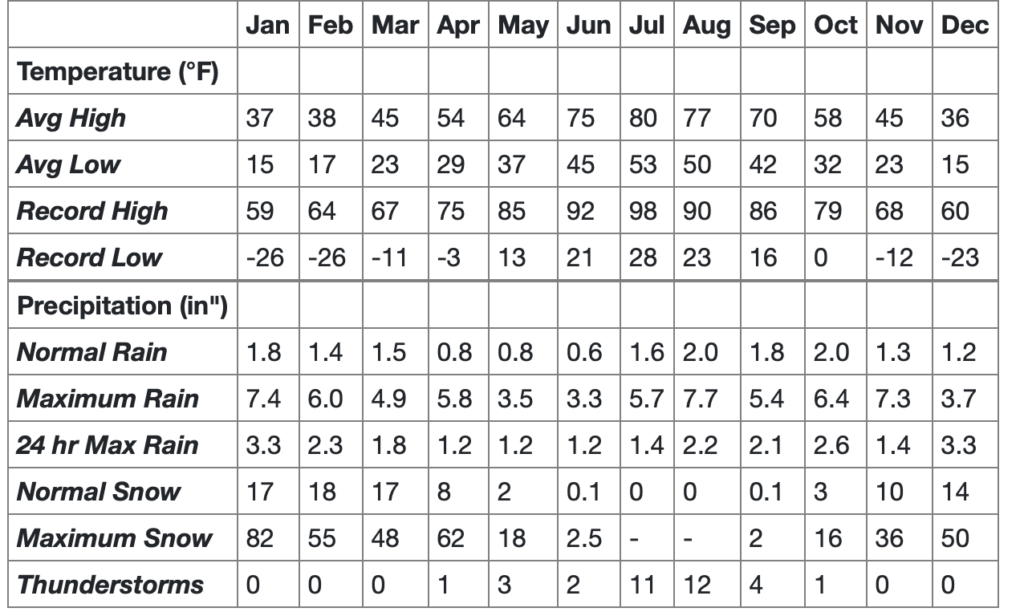
Gemiddelde max. temperatuur oktober 14,5°C – min. 0°C
![]()
- Parking: https://www.nps.gov/brca/planyourvisit/parking-information.htm
- Shuttle: https://www.nps.gov/brca/planyourvisit/shuttle.htm
Hikes
- Queens Garden & Navajo Combination
By far the most popular hike in the park and for good reason! This is the hike we most recommend to first-time visitors who are looking for a moderate hike to descend into the Bryce Canyon Amphitheater and walk amongst the hoodoos. The Queen’s/Navajo Combination Loop combines the open views and unique hoodoos of the Queen’s Garden Trail with the iconic switchbacks and towering canyon walls of the Navajo Loop Trail.
The Details
- Trailhead: Sunrise or Sunset Point
- Parking: Available at both Sunrise and Sunset Points; oversized vehicles are not permitted in these parking areas when the shuttle is in operation.
- Distance: 2.9 miles (4.6 km)
- Approximate Time: 2-3 hours
- Elevation Gain: 625 feet (191 meters)
- Difficulty: Moderate (less than 1000 feet elevation gain, moderate length)
- Services: Accessible restrooms available at Sunset Point (year-round) and available at the General Store near Sunrise Point (seasonally). Water-fill stations available at Sunset Point (seasonally), the Sunset Point restroom (year-round), and the General Store (seasonally).
- Shuttle Service: Yes.
- Pets are not allowed on this trail. Service animals are allowed in national parks. What is a service animal?
How to Get There
The Queen’s/Navajo Combination Loop can be accessed from either the Sunrise or Sunset viewpoints.
There are parking lots available at both viewpoints but being some of the busiest viewpoints in the park, these tend to fill up quickly. To avoid full parking lots we recommend taking the free park shuttle (April to October).
During shuttle hours, vehicles over 20 feet (6 meters) are restricted from parking in the Bryce Amphitheater area. Instead, park at the shuttle station and use the free shuttle.
How to Hike the Queen’s/Navajo Combination
This loop starts at either Sunrise Point or Sunset point and we recommend hiking it in a clockwise direction, regardless of which point you start the trail from. The most recommended route descends from Sunrise Point on the Queen’s Garden trail and ascends either side of Navajo Loop (Two Bridges or Wall Street) to Sunset Point. Complete the loop by walking the easy 0.5 mile (0.8 km) portion of the Rim Trail back to where you started the hike.
Why do we Recommend Hiking Clockwise?
- The views into the Bryce Canyon Amphitheater from the Queen’s Garden trail are in front of you when you descend the trail in this direction. Enjoy these views instead of losing them over your shoulder while hiking up.
- While it seems counterintuitive to descend the less steep Queen’s Garden, most injuries happen while walking down the steeper Navajo side of the loop. Help prevent injuries by ascending Navajo!
- When visitors are hiking a trail in the same direction it can help a busy trail like this one feel less crowded.
Wall Street Winter Closures
The Two Bridges side of the Navajo Loop is open year-round, however the Wall Street side is closed in months when precipitation combines with freezing overnight temperatures.
Where is Thor’s Hammer?
Thor’s Hammer can be seen from the Rim Trail near Sunset Point so you don’t need to hike the Navajo Loop to experience it. If you want to get a closer look, hike down the Two Bridges side of Navajo Loop. You don’t need to hike down too far to see it, just a few switchbacks will do!
Safety
Bryce Canyon is a high altitude park ranging from 8,000 feet (2438 m) to over 9,000 feet (2743 m) in elevation. Even mild exertion in the park can lead to altitude-sickness if you’re not prepared. Visit our Hiking at High Altitudes page to learn more.
Wear hiking boots with good ankle support and “lug” traction. In winter, traction devices are strongly recommended. Wearing shoes or boots not designed for hiking is the number one cause of rescues and injuries that require hospital visits at Bryce Canyon National Park.

21 oktober 2023
Daginvulling
Zion N.P.
![]() Entry Fee Zion N.P.: Interagency Pass
Entry Fee Zion N.P.: Interagency Pass
![]()
Weather Averages
Oktober gemiddelde max. temperatuur 26° C – min. 9° C
Hikes
- Riverside Walk
Shuttle Stop to Start from: #9 Temple of Sinawava
Pets: No
Trailhead Location: Adjacent to restrooms and water refill station.
Distance (roundtrip): 2.2 mi / 3.5 km
Elevation Change: 57 ft / 17 m
Estimated Hiking Time: 1.5 hours
Description: Minor drop-offs. Paved trail follows the Virgin River along the bottom of a narrow canyon. Trailside exhibits. The first 0.4 miles of the trail is accessible but past that point there are several steep slopes. Deep sand may be present on pavement after heavy rain. Some wheelchair users may need assistance.This trail accesses the bottom-up Narrows route (see below). Restrooms and water filling stations are available at the Temple of Sinawava.
Shuttle Stop to Start from: #9 Temple of Sinawava
Trailhead Location: Adjacent to shuttle stop and restrooms.
Pets: Not allowed
Distance (roundtrip): 9.4 mi / 15.1 km maximum
Elevation Change: 334 ft / 102 m
Estimated Hiking Time: 1-8 hours
Permits: Permits are not required for this hike.
Description
The Virgin River Narrows (via Riverside Walk) is a popular hike that begins at the Temple of Sinawava. At least 60% of the hike is spent wading, walking, and sometimes swimming in the river. Travel is rough and slippery in cold, fast flowing water, on top of slippery rocks. High water levels can prevent access sometimes. Use appropriate equipment and clothing to help protect you. Before your hike, always check the weather and flash flood potential. This hike is not recommended if there is a chance of rain in the forecast. Flash floods are deadly.
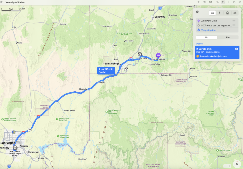
22 oktober 2023
Springdale – Las Vegas
Tijdzone Las Vegas
![]() – 1 uur
– 1 uur
- PDT — Pacific Daylight Time
- UTC/GMT -7 hours – 9 hours behind Brussels
Route
269 km
 Vluchtschema
| 16:10 Las Vegas, Harry Reid International Airport (LAS) Vluchtduur: 9h55 | 11:05+1 Amsterdam, Amsterdam Schiphol Airport (AMS) |
| Uitgevoerd door: KLM, KL1724 Toestel: Boeing 737-700 Reisklasse Economy Class To Check |
| 13:45 Amsterdam, Amsterdam Schiphol Airport (AMS) Vluchtduur: 0h50 | 14:35+1 Brussel, Brussels Airport (BRU) |
| Uitgevoerd door: Klm Cityhopper, KL1725 Toestel: Embraer 175 Reisklasse Economy Class |